Friday, June 26, 2009

John Boyd Thacher State Park, NY


So, after completing the return trip to Clarksville Caves, we needed something else to do to fill out the afternoon. Fortunately, the gentleman who was a representative of the Northeastern Cave Conservancy was also very familiar with the area's attractions of the outdoor type (my personal favourite), and he recommended that we go to the John Boyd Thacher State Park which was only twenty minutes away.

The predominant feature of the park is a huge ledge of limestone sitting on top of the local shales, surrounded by dense forests, waterfalls, and decent vistas of the Adirondack Mountains and the Green Mountains of Vermont. The views below are incredible, and in the distance it is possible to see the city of Albany, the state capital of New York.

He recommended to us the "Indian Ladder" trail, a trail that takes you along the bottom of the ledge. Named for the fact that the local Native Americans used to cut down trees, and then climb up them like a ladder, it is one of the most fossil rich areas in the world.


After the incredible drive to the Visitor Centre, we headed down to the trailhead where fortunately we were not forced to climb up and down trees as ladders as there is a modern, and very easy trail. Taking a close look at the Helderberg Limestones, you can easily spot the fossil remains of chrinoids and brachiopods.

Dotted all along this trail are numerous springs issuing from crack in the rock. The area's unique geology has provided the right coniditions for the development of caves and underground springs, many of which issue from this rock. However, long the way are numerous signs asking people not to climb on the rocks, mostly to safeguard them from getting injured on the way into the caves.


Along the trail are two waterfalls that cascade over the trail, however there was a mere trickle on our trip as there hadn't been much rain (until after we left).


The hike itself on the Indian Ladder is very short, less than half a mile, but this would be a good place for families or fossil-heads to visist, just please do not collect the fossils. For more information, please visit: the John Thacher State Park website. There you can also find a really decent map showing you the other trails. It is also the ending point for the Long Path, a trail that extends from New Jersey all the way into the Albany area.

Thursday, June 25, 2009

Marshall's Cave


Highland County, Virginia is a hotbed of cave exploration. Home to some of the longest caves in the state, the Chestnut Ridge cave systems and the systems of Burns Cove move massive amounts of water. And I do mean massive. The Butler-Sinking Creek system is now recorded to be seventeen miles long, and the related Chestnut Ridge System is fourteen miles long. The two are related hydrologically, as is nearby Aqua-Lockridge, and on the other side of the mountain is the Water Sinks System which is thought to possibly be a major contributor to the fridgid waters of Aqua, also known as Refrigerator Spring. Across the Cowpasture River is a small trail about a mile long that leads to one of my favourite places under-ground, called Marshall's Cave. When pondering the caving possibilities for the Boston Grotto/MIT caving trip back in February, this cave was one of the first that came to mind. I had last visited the cave about fifteen years prior, right before I left for college with my friend Christian, and I remembered being impressed with the absolute scale of the formations and the picturesque cave passages. This is not the longest cave I had ever been in, but it certainly was the most formated and large, complex horizontal caves I had ever been in.

After an evening of recovering from the Valentine's Day adventure of Site's Cave, and late evening debacle of locating Cave Rat Cave, finding out that we couldn't get into Cave Rat Cave through the horizontal entrance so aborting the trip instead of a hike in snow flurries to Kee's Cave in Franklin, this I felt would be the crowning jewel of our trip into the heart of West Virginia caving. True, Sites was very challenging from the technical aspect of rappelling and ascending out, but this cave would give us a good work out, and give me a chance to strech out my legs.


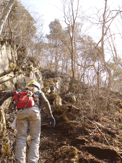
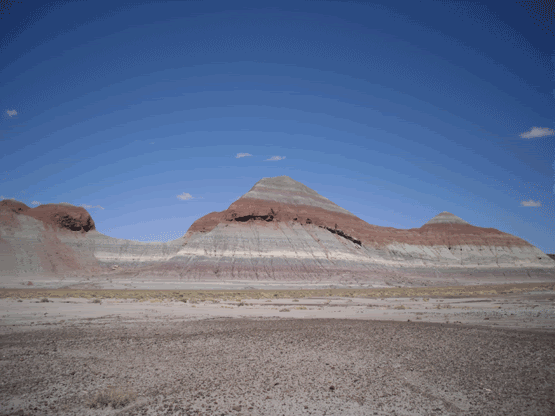
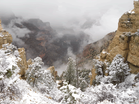
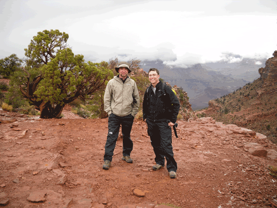
Genita and Darren had left us the night before, so it was just down to Keluo, Amy, and Madeleine who had joined us later the previous afternoon. We drove the thirty or so odd miles down a non-descript country road to the Bull Pasture Recreational Area near Williamstown, Virginia. Following the Cow Pasture River, you could smell cave, and the weather was quite mild, in the fifties, compaired to our weather back home in Massachusetts and New Hampshire.

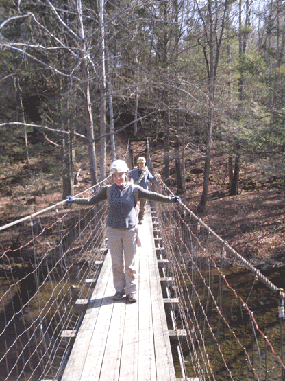
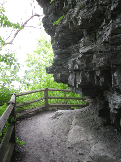
After locating the parking area, and gearing up, we headed across the suspension bridge to the far side of the river, and picked up the trail to the cave. The cave is not readily spotted since it sits high on a talus slope overlooking the river, and the only indication that you are close is when the trail crosses over a spring (which is the resurgence for the stream in the lowest level of the cave). Spotting the talus slope, we all turned up the faint trail. People do come to this cave, but my guess is that it is fairly infrequent. I have NEVER seen another group of cavers in it, and when I mention the name of Marshall's Cave, I usually get blank looks from many Virginia cavers. Either is it forgotten by most, or they just don't know about it.


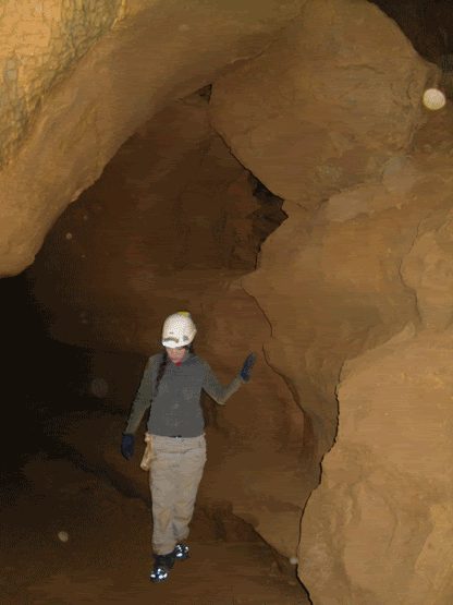
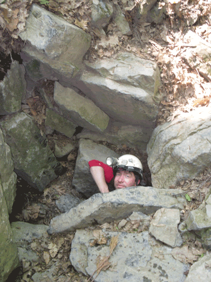
Amy and Madeleine lead the way into the cave, stopping to take pics of the small brown cave spiders that have made their home in the entrance area (for the squeamish, they are really small, and if you weren't looking for them, you would never really notice them). The passage is made up of grey limestone...even the formations are grey, and what formations are there, they have been broken off by vandals. However, we didn't come here to see the broken ones, and shortly we made our way through a few narrow squeezes before arriving at the pits that lead down to the middle level. Fifteen years ago I remember breaking out the ropes and rack to rappell down the twenty-five foot deep holes, but after a little investigation, the use of vertical equipment would be of no use, so we left the rope behind.

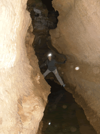
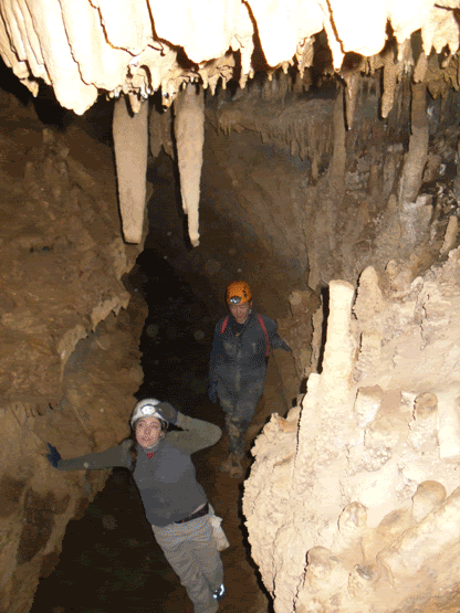
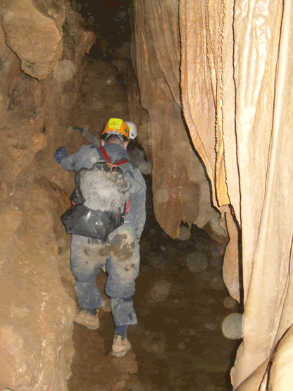
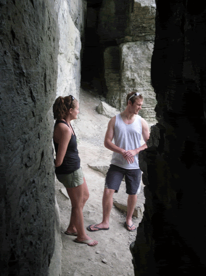
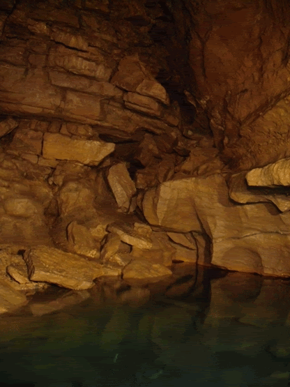
After this easy climb-down is where you first encounter the first major obstacle of Marshall's cave. Water. The water is so still that it is hard to discern where the water actually starts. But it is also here where Marshall's true beauty starts to show itself. The formations are active, still receiving the mineral laden water that slowly builds them up. The passage is a narrow canyon passage that you have to traverse by putting your feet on the opposite walls and "walk" across, hoping not to get into the cold water. This is easier said than done, as the formations partially block the passage, causing you to sometimes bridge yourself across, duck under formations, and occasionally climb...all while trying not to fall in. Keluo was the first casualty of the trip when he attempted a duck under that brings your face within a couple feet of the water, and his foot slipped and ended up thigh deep.

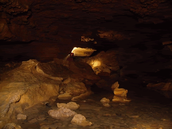
On about three occasions you reach a formation choke in the passage, and the only way to continue is up the wall, some of them with tricky hand and foot holds. For someone whi is trying to learn various chimneying and non-rope based technique, this cave is quite fun and offers opportunities for you to stretch yourself. Finally, after this third formation choke, and climb up the wall, there is a fifteen foot drop that you don't want to go down, and building up the confidence that you can do it, and your dependency upon friction can be a little disturbing at first, but not too difficult.


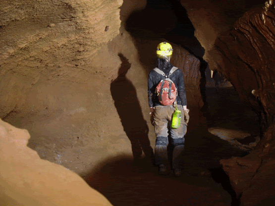
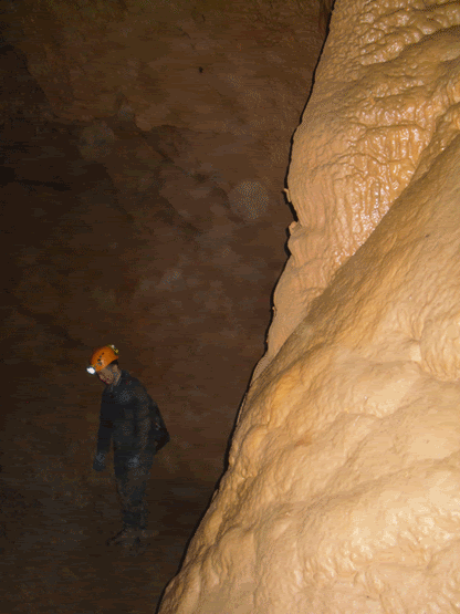
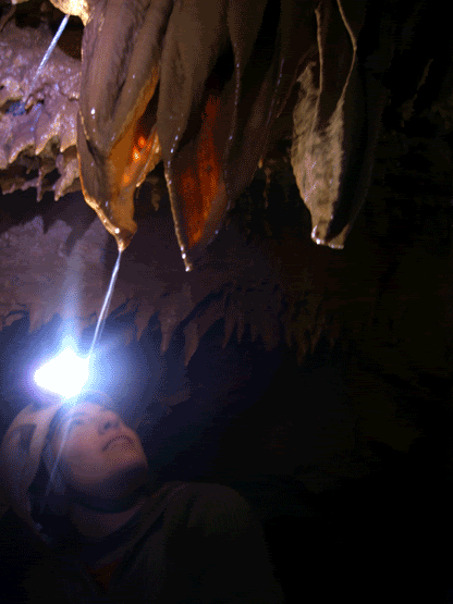
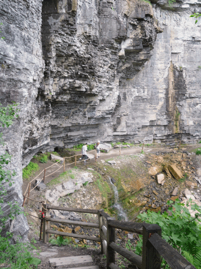
After crossing the drop, there is a climb down to the big part of the cave. It is a fairly tall canyon passage full fo large formations, mostly columns and flowstone that reach forty feet to the ceiling. Following this passage back, we spent quite a bit of time photographing the formations and the occasional bat. The passage quickly goes from walking to stooping, and then finally it appears to end. I remember fifteen years ago that there was a gypsum flower (a formation where the gypsum, usually a mineral of drier caves, almost seems to have been extruded from the rock like toothpaste) but it is gone. This could be due to increased moisture in the cave or, more likely, someone decided to take it home (where it turned into disappointing dust most likely).

To the rest of the group it almsot seemed like a disappointment...we had reached the end of the cave. Not quite ;) We turned around and headed back toward the entrance. Part way back the passage, I asked the group to stop and look by their feet. There was a small opening that lead into blackness. This is the entrance to the lowest level of the cave. After Amy slipped into the darkness, the rest of us followed, and then slid down to the bottom. It is here that the ceiling are really high, a good estimate is about seventy-five feet or so. It is also here that there is the stream that resurfaces at the spring that we crossed on the way in. Amy and Madeleine disappeared among the formations toward the back of the room. Keluo and I took some photos and I took the time to change my batteries. I was trying to encourage the group to take a sip from the stream, going against all presuppositions that one shouldn't drink unless it is from a tap, but it is the sweetest, cleanest tasting water I have ever had.


Marshall's Cave is located in the recreational area near Williamstown, Virginia. Though horizontal and following in pretty much a straight line so it would be difficult to get lost. However, that being said, please do not go caving unless you are with a minimum of three people, three independant sources of light and at least the basics of caving gear. If interested, please get in contact with your nearest grotto, or if you have any caver friends. The last I knew, this cave is currently closed due to federal and local governments folling the recommendations for the protection of bats from White Nose Syndrome. Though this is not a "bat cave" per se, it is the policey of many places that no one enter the cave to prevent the spread of this tragic condition afflicting our bats. As a caver, it is our responsibility to be like the Lorax and speak for the bats. We were very fortunate to have been able to get in the caving that we did in West Virginia and Virginia when we did since they closed the caves shortly thereafter. There are caves that are open, please check available web resources and with local grottos (caving clubs) to get information on what caves are available for entry.

Sunday, June 21, 2009

Painted Desert and the Petrified Forest


My second weekend in Arizona, I was on my own since my hiking partner and his girlfriend were purchasing their first home. We had discussed earlier the possibility of going to the Painted Desert and the Petrified Forest National Park, but since it was the day after devouring the Big Unit at Cooperstown, we were unsure of how we would be feeling the next day and decided to take it easy (taking it easy meaning a 3 mile round-trip hike up a mountain, then taking the "ENTER AT YOUR OWN RISK" trail to the summit of Pass Mountain in Mesa, Arizona. So, I made my first of several solo hikes into what was for me, one of the most bizarre landscapes I have ever been in.

The Painted Desert is a large area of barren badlands situated in the eastern part of Arizona, not too far from the New Mexico border. Driving east on I-40 toward Winslow and Holbrook, the landscape is flat rolling grasslands. Along the way is the occasional outcropping of red rock, Meteor Crater (I wanted to go, but it is privately owned and you can't even hike into the bottom of the thing which is ridiculous to me), and billboard after billboard advertising fossils and petrified wood for sale. When you finally pass through the whistle-stop town of Winslow (and I did not stand on a corner there) that you are getting close. You finally enter nearby Holbrook, turning south and then north, that you begin to enter the dry hills of the southern Painted Dessert where the Petrified Forest lays.

Long before you reach the visitors' centre in the southern end of the park you start catching glimpses of an eerie landscape. First, you descend into it. The bright light bleaching out all colour at first, but once your eyes become adjusted, bands of colour: reds, bright whites, blacks and varying hues of pink and grey that all combine into a fantastic display of colour and geological tale telling.


Arriving at the visitors' centre, is your first trail at the Rainbow Forest. This easy trail, meandering over sparse grass covered hill gets you up close to large petrified logs of conifer trees that once covered the landscape millions of years ago. Upon close inspection, you can even see quartz crystals and amethyst that formed over time.


Completing this trail, I continued further north and was in shock. Where were the trails? I finally came upon the next trail at the Crystal Forest, another long meandering trail that takes you past the petrified remains. Not that I wasn't impressed, but I was hoping for something more than the few trails offered so far. However, the next trail at Blue Mesa, three miles off of the main road running northward through the park offered a little more challenge and a completely different landscape. Previously, where the landscape was more rolling hills, here the trail took you into badlands, which I can not really describe adequately in words. Its like walking on the moon. There were far less people on this trail, which to me, was more like it! Walking down through the deep gorges through the hoodoos, it at first looked like someone just spread out bark mulch all over the ground. Out of curiosity, I cautiously picked up a piece (the National Park is very protective of the petrified wood and they do have a checkpoint where they check out your car to make sure that you are not taking anything out...so I did not want to give the wrong impression to the passer-by), and much to my amusement what I had thought was bark mulch was actually a chip of petrified wood...petrified mulch.


Once I completed the trail, I continued north to Pueblo Puerco, the ruins of a small Native American settlement overlooking a nice canyon. Etched in the rock, just below the rim were a series of pictographs, still visible. Very Very cool to see!


Well, it was here that the answer to the big mystery of, "Where are all the trails here?" was finally answered by a Park Ranger...there aren't any...as it turns out, as long as there is not a sign stating that one cannot walk through a particular area, you can simply pull your car over and walk off. Now, if you were to do this in our neck of the woods (literally) there are two possible outcomes: 1) You'd be lynched, 2) you would get lost and search and rescue would come and try to find you, and if you are not dead, you will be responsible for paying for the bill. So, I decided to make a date with the badlands I had passed earlier.


Let me tell you, setting foot out onto the parched clay surface of the badlands and leaving the only visible foot-prints is an odd, kind of nauseating but great experience. The Benonite clay getting compacted under your shoes, the total sense of being alone...almost spiritual. Once I was far out enough to no longer see my car hiding behind a hoodoo, I decided it was time to pack it in and call it a day. Upon arrival back to the car I saw three ravens circling it. I'm pretty sure that is an ominous portent...but I made it home safely.

Just a few tips: Bring water! Enough for you to complete your hike and then some. WHEN YOU ARE HALF-WAY THROUGH YOUR WATER YOU ARE HALF-WAY THROUGH YOUR HIKE. Also bring plenty of sun-screen so you don't fry yourself like I did.

For more information on the Painted Desert and the Petrified National Forest, please visit Petrified Forest National Park.

Clarksville Redux


May 23rd we revisited Clarksville Caves just outside of Albany, NY. As I am trying to light a fire under some friends' tails to get caving ('cause after all, the world could use a few more responsible cavers out there). We drove down the previous Friday evening hoping to arrive at the hotel before 11:00 om (like the last time), and after some crafty maneuvering on my part, we arrived just after ten o'clock (I don't drive like a granny ALL of the time).

So, after a good night's rest we arrived at the now familiar sink of Ward-Gregory, aka Clarksville cave. We found that we were the second vehicle to arrive, the first person was a very informative gentleman who happened to be a representative of the Northeastern Cave Conservancy (and is also the warden of nearby Onequethaw Cave, a very wet cave with some notorious features such as "The Barnyard"). He asked us if we were familiar with White Nose Syndrome (a disease that is responsible for the death of approximately 1,000,000 of the hibernating bats in the affected area, some of which are the endangered Indiana Bat Myotis sodalis and the adorable Virginia Big Eared Bat Corynorhinus townsendii virginianus. The fungus has just been classified and more can be read about it here). I explained that we were, and of my recent trip down into Virginia and West Virginia and what we had found there.


So, we headed into the cave, this time our goal being to get better pictures than the last (caves have the amazing ability to swallow light as it turns out), and to finally make it back to the Lake Room, a goal that we fell just short of as it turns out the last time we were in.


Clarksville is always a joy to go into, even though it is well visited. The recent good rains had raised the stream level a bit, but nothing that the use of wet-suit socks couldn't keep at bey. After reaching the point where we had stopped the last time (just upstream of the Thook Passage and Pictograph Crawl, I scouted ahead through an up-climb and found the passage dropped back down into a pleasant if not wet walking passage. The trick was to get everyone else to do it! After a little cajolling, and allowing the novices to lead, we made it through and came upon the Lake Room. After a few minutes of picture taking (this time with a mini-tripod and using Keluo Yao's light painting technique) we headed back through the crawl to the main passage. One more stop for picture taking (and did a not too shabby job), we headed out for some lunch at the neaby, recently re-opened establishment called June's for some hot coffee and brunch. All in all, a sucessful introductory trip into Clarksville Caves.

The South Rim


 So, I know that this blog is dedicated to mostly travel and exploring the North East, however on occasion, thanks to my job, I get to do some travel outside of my favourite geographical area. So, I had the opportunity to work in one of our locations in Phoenix, Arizona. Never having been to Arizona, I was really looking forward to getting out into the desert, and my first choice of places to go hiking was at the South Rim of the Grand Canyon. Dessert usually equals abundant sunshine and heat, right?
Not on this day. Saturday, April the 18th we knew was going to be interesting. Though the temps in the city of Phoenix were forecasted to be in the upper sixties, it was going to be raining like hell. My co-worker J and I left the hotel around 6:30 am and started heading north on I-17 in driving rain and some wind, only to find just around Prescott that the rain changed to a steady wet snow. But, we live in New England where people will drive in twelve inches of snow just to get to the mall without giving a second thought.
When we reached I-40 out of Flagstaff, the snow backed off and everything appeared that it would be ok. We took our exit to get to the National Park, and as soon as we hit the border of the park, the snow came back in with a mix of rain for good measure. Finally arriving at the Visitor’s Centre, we discovered that we were going to need some extra clothing for comfort, so we made the trip to the trading post one mile away from the rim, unintentionally getting the same rain pants and similar outer shells making us look like either cult members or people from a running team. But it was good that we stopped in, as the clerk who helped us out gave us a suggestion of a hike into the canyon. He recommended South Kaibab trail to Cedar Ridge, explaining that the views, of which there were none due to the weather, are better than Bright Angel and that there is less foot traffic.


So, after returning to the Visitor’s Centre we caught the bus to the South Kaibab trail-head at about 7,000 feet in elevation (my first time hiking at a higher altitude than Mount Washington which is the highest point in the North East. At the trail-head there is a mule team used to bring supplies down into the bottom of the canyon, and as a word of warning while on the trail, get out of the way of the mule team as they go down or up, and also watch your step as there is a significant amount of mule poo.


My first thought was how much it was going to suck not being able to see much in the way of views. To visit such an iconic part of the western American landscape and not be able to see the classic sights that so many before us had seen, but then again, how often does an easterner get to hike the Grand Canyon AND can see that they have seen it frosted with snow. I began to cheer up a bit at this though. Interestingly enough, every half hour to forty-five minutes the snow and rain would back off and the fog would lift just enough to begin to see the true scope of the landscape we had entered. Kind of like those first moments that you open your eyes from sleep and not quite everything is in focus. Bands of red rock, darker bands almost black, the trail nothing more than a red-clayed path leading further down, and then across the void barely glimpsing the opposite wall through atmospheric haze…then once again the rain and snow came back obscuring everything like some long and somber dream.


We encountered a few people on the way down into the canyon, most on their way back up, some carrying heavier loads from a backpacking trip from the day or week before. After about two hours worth of hiking we finally reached our intended destination, 2,000 feet below the rim at Cedar Ridge, a broad plateau overlooking the Colorado River (which try as we might, never did get to see). There were a few educational displays, and the chemical toilets were a welcome sight. Here there were, as the name suggests cedar trees as well as the dead dried-out stalks of yucca and dried shrubs.


Finally it was here that blue sky and the sun began to peek through, and standing on the edge, through the haze we could see only mile after mile of buttes, mesas, and the maze-work of streams thousands of feet below that have sculpted the red rock into one of the most incredible sights man has ever laid eyes on.


After the hike up and out, we were greeted by a small herd of Mule Deer just hanging out by the cars at the trail head. We were able to get surprisingly close (though we decided to not get too close. Snapped a few pictures. After the short bus ride back to the Visitors’ Centre where we parked, we could hear thunder rolling in the distance and got the eerie treat of listening to the thunder echo through the canyon. Simply incredible. So, here is the list of weather we got to experience:

  • Rain
  • Snow
  • Hail
  • Sleet
  • Thunderstorm
  • Sunshine


It was time to return to the hotel and catch up with the rest of our crew for the Big Unit Challenge at Cooperstown in Phoenix.


The South Rim of the Grand Canyon is open year round, and can be easily reached from Phoenix, AZ by taking I-17 North to I-40 West. Take the exit for I-64 West and follow this to the South Rim entrance to the Grand Canyon. For more information and directions visit the National Park Service website http://www.nps.gov/grca/