Sunday, November 9, 2008

Have you ever danced with the Devil in the pale moon-light?


I know it has been a while since there has been anything new added to NET, and I apologize, things being hectic with work and travel. And admittedly, the template that they give you for these thingies on Blogger are not all that...exciting? But its a template, and fortunately they permit you to make adjustments. Finally got my act together! :) So, here is a trip from 2008. More is on its way!


No, I haven't, nor do I think the Devil would like to dance with me...I've got two left feet, I have no rhythm, and well...that's just not quite how I roll.

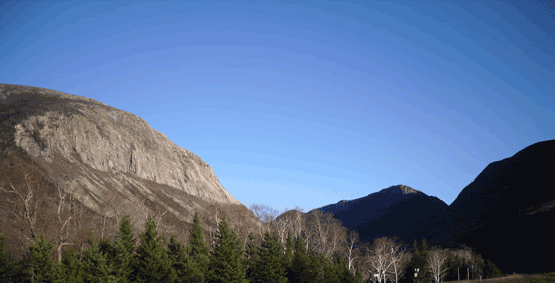
But somewhere, perched high on a mountain-top, whose bald granite skull peeks through the growth of hemlock trees, staring grimly down upon Lake Winnipesaukee and Merrymeeting Lake outside of Alton, NH, the Devil has made his home inside this dark, wet and cold granite tomb. I had read about the Devil's Den in Haunted Hikes of New Hampshire by Marianne O'Connor (leave it up to the Irish to find the spookiest stuff around...I'm about 3/4's Irish, so don't bad-mouth us!), and is probably my favourite source for the spooky hikes of my adopted state. Evidently, the earliest accounts of exploration of the Den left Eathan Allen Crawford and some climber named Leavitt (according to Ms. O'Connor's book) shaken when they discovered human remains in the entrance. But a later party who entered the cave found neither the Devil nor the aleged human remains. Also, the Devil evidently likes living in New Hampshire since he made several "Dens" throughout the state, not just this one in Crawford Notch, but also in Barrington and Nottingham, NH (damn that Devil gets around).


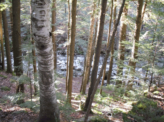
The trail is not easy to find, and the cave itself is even harder. Taking Rt 11 heading north to Alton,NH you reach the traffic circle, take your immediate right as you approach (this is New Durham Rd). This becomes Main St. At the Fish Hatchery take a left. Eventually the pavement ends right around the point that the road takes a sharp right. You want to find parking around this area, but careful not to block in anyone's driveway. Straight ahead is a dirt, very rugged road that takes off up the mountain. This is the ATV trail that you want to follow, just mind the people on three and four wheelers...they will see you and slow down, they were rather friendly and waved and gave plenty of room. Now that you got that part down, you just keep walking. Eventually you will reach a beaver pond on the left side of the road, and the road starts an upgrade toward the top of a hill. When you reach the crest, keep an eye out for the trail-head on your left.

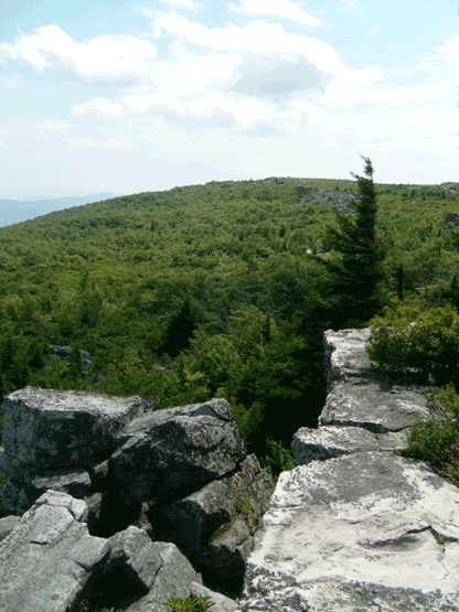
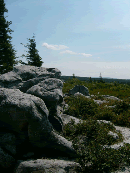
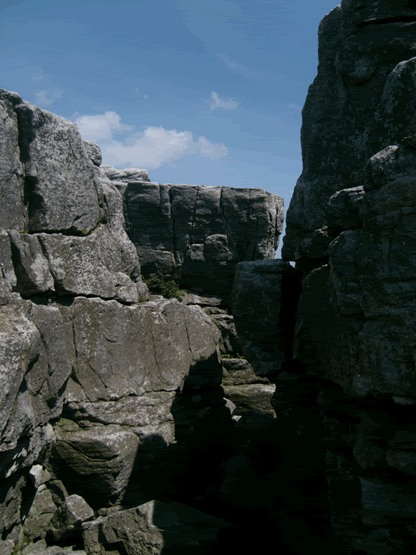
The trail is actually a very easy hike, and the rock formations are damned impressive. Eventually you will reach the peak of the mountain, with spectatular views of Merrymeeting Lake and Lake Winni in the distance (if you are trying to figure out which is which, the reeeeeeeeaaaaaaaaaaaaaallly big one in Winnipesaukee). From the top of the mountain the trail continues down the other side. If you are looking for the Den, this is where things get rather tricksy. The very narrow trail makes a few switchbacks. You will eventually reach a ledge in the middle of the trail (where it takes off steeply through the woods), and you want to bear LEFT LEFT LEFT...up over some boulders, and then the entrance is a gaping maw into the cliff face (even my description is confusing and hard to find).


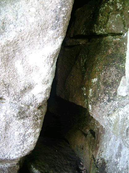
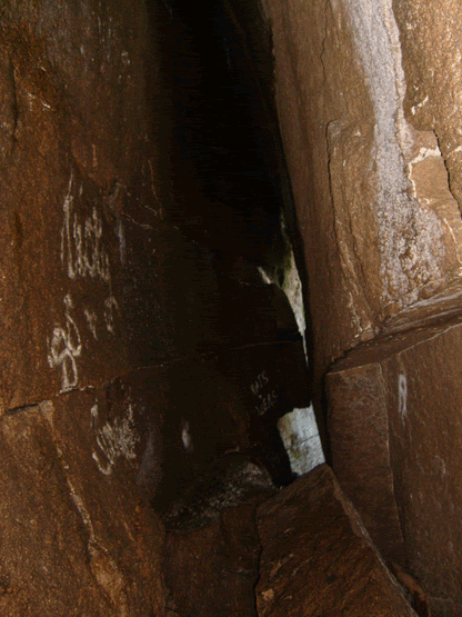
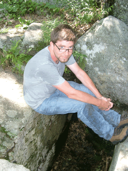
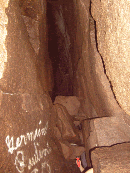
The cave itself is only about thirty five feet long and about 15 to 20 feet high. It never widens out beyond your fingertips if you spread your arms out. And it is cold, and it is wet. A flashlight is good to use, but I recommend a head-lamp to free up your hands, you will need them for balance. When you finally reach the back of this crevice, tucked in a slight corner to the left, you see daylight and a ladder leading you to the upper entrance. Right now I don't recommend using the ladder, it is slippery, missing a few rungs, and well...its not attached to anything at the moment...I hope to make it up there sometime in the Spring and secure the ladder so no one gets seriously injured.


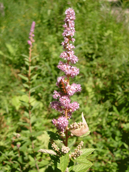
But, as far as New Hampshire caves go, it is actually pretty fun, the sights from the top of the mountain are great, and if you time your visit right, the blueberries will be ripe. Well for the half day it takes to visit the mountain and the cave.


Sunday, November 2, 2008

The Keeper of Lost Ladies


Nestled high in the White Mountains, only eight miles from the breath taking Franconia Knotch,
is the most photographed waterfall in the state of New Hampshire. The Coppermine Trail branches off of the Coppermine Road on the southward direction of Rt 116 (easily reached from I-93 North). The morning was, to use a New England euphamism, "wicked cold", about 28° F. The main attraction to getting up at 4:45 in the morning was a combination of wanting to try out the winter gear (really, how warm can all of these layers of thermal wickable material keep you? As it turns out, very! And also, since it being the weekend of Hallowe'en (my favourite holiday), it was rumoured that there is a ghost-town somewhere in these hills.


The story goes like this. The European settlers, under the belief in manifest destiny, and being given "dominion over the earth and subdue it", found a particularly rich vein of copper in the area, and started to build their town. However, when they returned in the morning, they would find the previous days work dismantled. They questioned the native americans who were snickering behind their hands (I'm guessing), and it was explained that the spirits didn't want them to build there (it was a burial site), and would dismantle their labours. They tried and tried again, the buildings were repeately taken down as if my magic (or gremlins). Eventualy they just gave up, and only the foundations remain as a testament to their follies.


The other claim to fame for the area involves the lovely actress Bette Davis. Tired of her life in superstardom, and basically at the beck and call of Warner Bros, the longed for the romance ad stark beauty of Franconia Knotch, and it was here that she purposfully got lost at the end of the Coppermine Trail at Bridal Veil Falls, and was rescued by the object of her affection, Mr. Arthur Farnsworth. They fell in love, but as befitting of moviestar love, it ended tragically with his death. Evidently Bette left a plaque on a boulder in the middle of Coppermine Brook, dedicated to Arthur "Keeper of Lost Ladies" Farnsworth. I did search for this plaque, but couldn't find it at all, but I will look again in warmer weather.


The trail is roughly two and a half miles long, is mostly level with only a few up-grades, and is a great hike. Along the way, the brook had frozen on low hanging branches, and there were ribbons of ice that looked alot like the "gypsum flowers" found in some caves. Just watch your footing on some of the rocks in te trail as they are loose, and the falls themselves at the end of the trail were well worth the early morning hike and freezing temps!

Tuesday, October 14, 2008

Dolly Sods, West Virginia


This is one of my favourite places on earth. My father is an avid gardener and backyard naturalist, and his beard is six times the size of mine. As a child we would frequent the area of Dolly Sods, a high plateau of very unusual geological features and what makes it even more unusual is its Canadian taiga plant life.


At one point this was the eastern most shore of the continent of North America, as is evidenced by the conglomerate rock (its kind of like concrete made of sandstone with large quartzite pebbles) and pure white quartz sand. The headwaters of Red Creek and its beloved hiking trail begin from the cranberry bogs where you can walk on top through marked trails on the spongy earth, and then descending through the Blue Spruce forest and a torrent of waterfalls. To make it even better, surrounding the bogs and the spruce trees is square mile after mile of wild blue berry bushes and they are free for the picking (I argue that West Virginia wild blue berries rival those of Maine and New Hampshire).

So, the day before I was to return northeast after my grandfather's funeral in Johnson City, TN my father suggested that we go to Dolly Sods. I don't know that I had ever been so excited to go, it had been about twelve years since I had been up there, and growing up this was my playground.

The sandstone is carved by wind and rain and the relentless volleys of winter, and looms like castle turrets from the undergrowth of blueberries. While most children were building forts in the woods in their back yards, I had these ready-made forts that could withstand the assault of pine cones, rocks and mud.


I showed pictures once to a friend of mine who lives in Volgograd, Russia. She referred to it as a dismal dreary place. It is true; the plateau does have its own peculiar sullen charm. Clouds can roll in a moments notice, a light drizzle, and a frigid wind. The air is even thinner, sound doesn't travel the same. Its beautiful and spooky at the same time.

This day however that my father and I went to pick blue berries was far from dreary but yet brutal from the sun. I spent a good three hours picking blue berries (I got half a gallon to bring back home) before I realized my sun burn was going to be bad. Really bad. So, while wandering, I found a neat little hollow and saw something brittle and white. I found bleaching deer bones, skull, ribs and vertebrae, likely the victim of the weather and then scavenged by coyotes. Then I made my way to the precipice of Bear Rocks, attempting to find a little shelter from the sun in the many crevices and boulder caves that I used to crawl and climb through as a kid.


The Dolly Sods Wilderness area is free of charge, and is located on Rt. 55 near Elkins, West Virginia in the Monongahela National Forest. It offers spectacular scenery, hiking, wilderness backpacking, groomed camping areas for those who don't wish to "rough it", and just abundant West Virginia wilderness that is simply unrivaled. More specific directions can be found on the Wilderness area's website http://www.fs.fed.us/r9/mnf/sp/dolly_sods_wilderness.htm. I strongly suggest sturdy shoes, and dress appropriately for the season. Even in summer the temperature difference between the bottom at nearby Smoke Hole Caverns (another cool spot to visit) and the top of the escarpment can be significant. Other nearby areas of interest are Spruce Knob, Germany Valley (excellent caving), the world class climbers' spot Senneca Rocks, and much much more.

Monday, October 13, 2008

Pawtuckaway Boulder Fields


Located in Nottingham, New Hampshire is a phenomenal and not very well known gem called Pawtuckaway State Park. I frequent the area on a regular basis during the late spring and summer months in search of its native orchids (especially Goodyera pubescense), to roam among the boulder fields, rappelling from the Lower Ledge much to the irritation of the rock climbers who feel that they have some sort of superiority over everyone else who wishes to practice the vertical arts, and I just recently located the Devil's Den heading toward the peak of North Mountain.

First of all, and I have to put this as a byline for visiting Pawtuckaway State Park, because I like to go into the less public area (which for now is free unlike the main entrance if you want to go swimming or fishing at Pawtuckaway Lake), please be aware that the road off of Reservation Road is very rough and must be driven slowly. Also, please be aware that it is quite possible that you will lose a tire just as I did shortly before I left for Washington, DC for a week. The locals and other people who feel that because they drive a four-wheel drive vehicle like to drive at a pace that can only be described as reckless, as is evidence by how rutted and torn up the road is. Drive slowly and patiently, please.


The Boulder Field is my favourite place to visit. A glacial cirque that developed as the glaciers tore down the walls of one of the few volcanic mountains in the area, and secondary growth of oak, maple and hemlock trees, the paths are winding and shady, sheltering an incredible variety of mushrooms both edible and poisonous, racing snakes, small rodents and marshland perfect for watching predatory birds, Great Blue Herons and a choir of frogs, this place is captivating, relaxing and well worth the visit.


If you are into the adventure aspect, the boulders offer some convenient and top class climbing, and the lower ledge, a massif of rock overlooking Dead Pond soars 65 feet above a pine needle floor. A trail leading off from the Boulder Field winds its way toward the sullen peak of North Mountain, where right before you start the more serious ascent, the gaping maw of the shelter cave called Devil's Den offers the hiker the opportunity to relax in the cool breath of the mountain as it escapes from somewhere in its depths.

For a map and directions, visit http://www.nhstateparks.com/paw.html